Route 66 crosses Arizona with some of the most scenic and historic stops along the entire highway.
Here’s how to plan your drive from New Mexico to the Colorado River, including national parks,
roadside icons and RV-friendly tips.
Arizona is Home to the Most Beautiful and Diverse Part of Route 66
The most famous highway in America is celebrating its 100th birthday! Route 66 opened in 1926,
connecting Chicago to Los Angeles while covering nearly 2,500 miles passing through eight states.
While most of “The Mother Road” has been replaced by freeways, you can still largely follow the
original path. Look for “Historic Route 66” signs on maps and along roadsides as you travel.
We think Arizona has the most inspiring section of Route 66. As it traverses the northern part of the
Grand Canyon State, the route passes through or near two national parks and four national
monuments. Then, there are classic Route 66 sites like the Wigwam Motel, Standin’ on the Corner
Park and Meteor Crater. It’s an unforgettable road trip defined by human history, geological wonders
and wild donkey meet ‘n greets.
What’s the Best Time of Year to Visit?
Northern Arizona sits at high elevation, and winters can be cold and snowy while summers are hot,
dry and dusty with occasional monsoons. So spring, fall and early summer are ideal for exploring.
West of Flagstaff, Route 66 and I-40 descend from about 7,000 feet to the desert below, and in
addition to elevation changes the temperature will be very hot in the summer. Be on alert for high
winds, too.
How Long Does It Take to Drive Route 66 in Arizona?
If you drove Route 66 across Arizona from the New Mexico border to California, the 385-mile trip
would take about 6.5 hours. But that’s without stopping. Here are twelve of our favorite can’t-miss
attractions. Some are located right off I-40 while others involve a lengthier detour. Depending on what
you choose to see, we recommend three to seven days for this road trip.
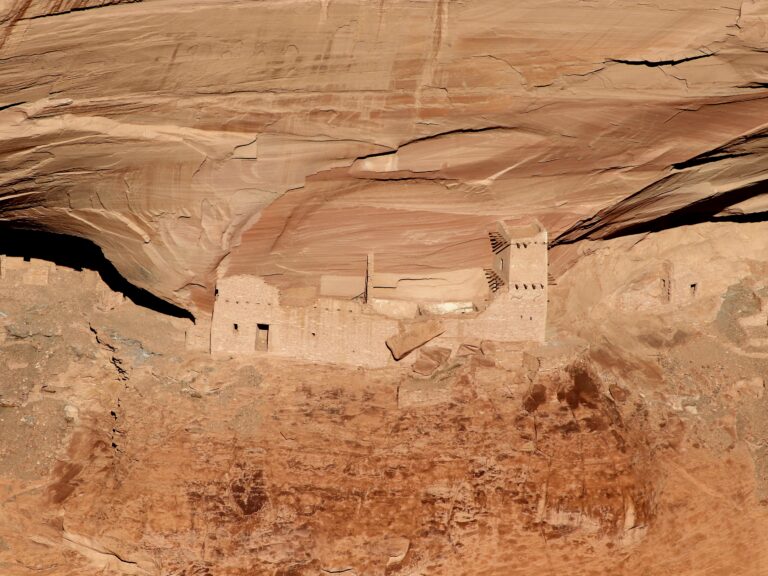
Highlight 1: Canyon de Chelly National Monument
From New Mexico, Route 66 crosses into Arizona as I-40, a busy freeway and major east-west
trucking corridor. At Chambers, 26 miles west on I-40, head north on US 191 to our road trip’s first
major site. Canyon de Chelly National Monument is located 77 miles north of Route 66, deep in the
Navajo Nation. But it’s worth the detour to drive high along the canyon’s rim, stopping at several
overlooks. Peering over the edge, you can see ancient dwellings built precariously into the cliffs. For
nearly 5,000 years, people have lived in these canyons and far below Diné families continue to live
and farm on the valley floor. Spider Rock Overlook is another highlight where a brief hike leads to a
stunning view of an 800-foot sandstone spire.
Time: Plan at least a full day to reach Canyon de Chelly and drive to the numerous overlooks. Tours
into the canyon by vehicle, horseback or hiking are also available.
RV driving and parking: US 191 and the park’s two roads, South Rim Drive and North Rim Drive,
are paved and well-maintained.
Camping: Located near the visitor center, Cottonwood Campground is a peaceful, shaded
setting with large, old-growth cottonwood trees. There are no showers, hookups or reservations: sites
are available first-come, first-serve.
Highlight 2: Petrified Forest National Park

Back on Route 66 and I-40, it’s 22 miles from Chambers to another gem in the national park system.
All northern Arizona is a geological marvel, with natural forces sculpting the colorful landscape into
buttes, canyons and pinnacles. Petrified Forest showcases this terrain while featuring another
element: hikes past ancient fallen trees, transformed into stone over millions of years. Crystal
Forest is the premier trail for petrified wood, but many other hikes and short walks through grassland
and the Painted Desert give close-up views of nature’s artistry.
Time: The national park lies along Route 66 and connects directly to Petrified Forest Road, a paved
28-mile scenic drive leading to all major overlooks and trails. The road travels south, ending at US 180.
Go west 18 miles to Holbrook to pick up Route 66 and I-40.
RV driving and parking: Petrified Forest Road is an easy drive for RVs with ample parking at overlooks.
Camping: There’s no camping or overnight parking allowed.
Highlight 3: Holbrook & Wigwam Motel

With campgrounds, restaurants, grocery stores and fuel, Holbrook is a welcome respite. It’s also
where you’ll find the Wigwam Motel, one of the most enduring attractions along Route 66. Officially
known as Wigwam Village #6, the fifteen concrete and steel teepees date back to 1950. They’re
modeled after Historic Wigwam Village #2 which opened in 1937 and still operates in Cave City,
Kentucky. Listed on the National Register of Historic Places, Arizona’s Wigwam Motel is open for
stays, too, and features original handmade hickory furniture, air conditioning and a small bathroom
and shower. The nostalgic theme continues throughout the motel’s grounds with a collection of
vintage automobiles and a museum displaying memorabilia from the original owner.
Highlight 4: Winslow & Standin’ on the Corner Park

From Holbrook, continue 33 miles west to another important town along Route 66. In downtown
Winslow, you’ll find souvenir shops, a brewery and Standin’ on the Corner Park. In 1972 the iconic
American rock band, The Eagles, released the debut single, “Take It Easy” which includes the line,
“Well, I’m a standin’ on the corner in Winslow, Arizona with such a fine sight to see. It’s a girl, my lord,
in a flatbed Ford, slowin’ down to take a look at me.” To commemorate one of The Eagle’s most
famous songs, the town created a park with a mural, statues and flatbed Ford.
Highlight 5: Meteor Crater

This otherworldly site is one of Route 66’s most astonishing attractions. From Winslow, it’s 20 miles
west to the Meteor Crater exit and then six miles south to a large parking lot. Set against a hill, the
modern visitor center is the entry point for expansive views of a massive bowl-shaped depression
that’s 700 feet deep and stretches more than 4,000 feet across with a circumference of 2.4 miles.
Meteor Crater was formed some 50,000 years ago when a gigantic meteorite or a dense cluster of
meteorites struck the ground with a force greater than 20 million tons of TNT.
Time: It’s a quick and easy drive on a paved road to Meteor Crater. While it only takes a few minutes
to absorb the incredible view, the visitor center has a museum, theater and coffee house so plan on a
A couple of hours’ visit.
Camping: Meteor Crater has a campground with 71 RV sites and 36 full hook-up sites.
Highlight 6: Walnut Canyon National Monument

Back on Route 66 and I-40, it’s 29 miles to exit 204 and Walnut Canyon National Monument. Located
just outside Flagstaff, humans have explored, lived and farmed in the canyon for centuries. During the
1100s, the Sinagua people constructed dwellings below the canyon rim. Walking the one-mile loop
trail gives up-close views of several cliff dwellings in a magnificent, forested setting.
Time: Located just off Route 66, this peaceful escape only takes a couple of hours to explore.
Camping: While there’s no camping at Walnut Canyon, the U.S. Forest Service runs several
campgrounds in Coconino National Forest and the Flagstaff area.
Highlight 7: Sunset Crater Volcano National Monument

As if breathtaking stone formations, petrified wood and a meteorite weren’t enough, volcanoes also
played a part in shaping northern Arizona’s remarkable landscape. From Walnut Canyon and Route
66, follow US 89 north for 15 miles to Sunset Crater Volcano’s entrance. A thousand years ago,
Arizona’s most recent volcanic eruption took place here, forming the lofty cinder cone. Loop Road
travels east through the park, where short hikes pass through lava fields. The route connects to our
next highlight as Loop Road is also Wupatki National Monument’s main highway.
Camping: Located across from the visitor center, Bonito Campground has 44 campsites.
Highlight 8: Wupatki National Monument
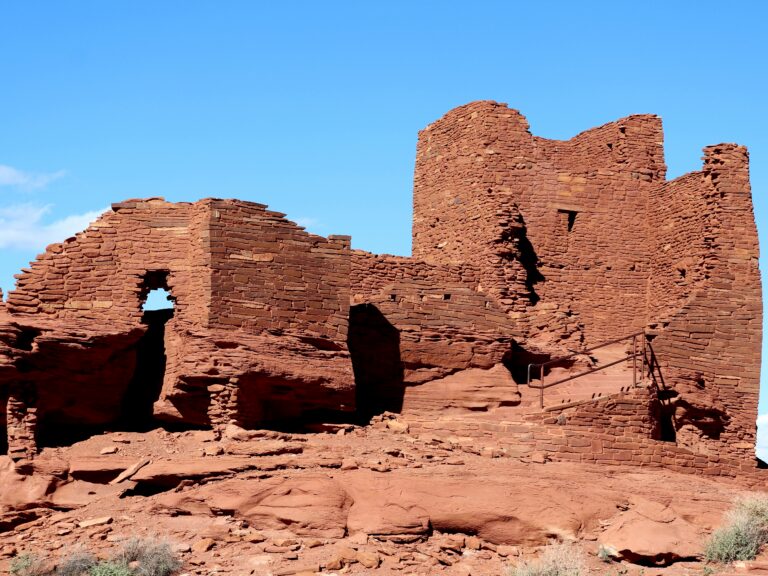
Continuing north on Loop Road, from Sunset Crater Volcano, it’s about 17 miles to Wupatki and the
impressive remnants of a once-thriving community. At first, it might seem like the two neighboring
national monuments have nothing in common. And yet, the pueblos of Wupatki represent a time
when the area bustled with life. During Sunset Crater Volcano’s eruption around 1085 CE, people fled
the immediate area, causing nearby Wupatki’s population to boom. The volcanic ash also improved
soil moisture leading to successful crops. Wupatki became a flourishing regional trade hub with multi-
level masonry pueblos, such as the park’s namesake pueblo with 104 rooms, a ballcourt and natural
blowhole feature.
Camping: While there’s no camping at Wupatki, the Bonito Campground is located across from
the Sunset Crater Volcano visitor center.
Highlight 9: Flagstaff

The largest city along Arizona’s Route 66 lies at the base of the state’s highest mountain, 12,633-foot
Humphreys Peak. Outdoor-oriented 7,000-foot-high Flagstaff is hip and happening with bike shops,
breweries, coffee shops and numerous campgrounds. For selfies, there are plenty of Route 66 road
signs and two downtown murals to photograph: the Phoenix Avenue Route 66 mural and another on
the side of the Amtrak train station. At night, cruise by Route 66’s many motels looking for neon signs,
like the Western Hills Motel’s famous stagecoach.
Highlight 10: Grand Canyon National Park – South Rim

Another monumental detour lies 80 to 90 miles from Flagstaff and Route 66, depending on which
highway you follow. From downtown, US 180 is the most direct approach to the Grand Canyon’s
South Rim, but you can also continue west on Route 66 and I-40 to Williams and then head north on
State Route 64. About the size of Delaware, the massive national park occupies a big chunk of
northwestern Arizona. The Grand Canyon is 278 miles long and averages one mile deep and ten
miles wide from rim to rim. Most people visit the South Rim with numerous overlooks providing bird’s-
eye views of this geological masterpiece, carved slowing over millions of years by the Colorado River.
Time: It’s an easy drive on excellent highways to the Grand Canyon. Desert View Drive, the highway
following the South Rim, is well-maintained although at 7,000 feet high, snowstorms shut it down from
time to time. Budget a full day to reach the park and enjoy the viewpoints and visitor center. Unlike
most other attractions along Arizona’s Route 66, this very popular park gets crowded so plan
accordingly. Summer and spring and fall school vacation periods are particularly busy. The park also
runs shuttle buses in spring, summer and fall.
Camping: The park operates seasonal and year-round campgrounds. Sites book fast and reservations can be made up to six months in advance.
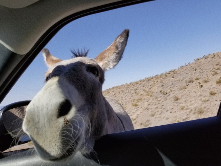
Highlight 11: Oatman’s Wild Burros
Returning to I-40, the westward journey on Route 66 continues. From Williams, it’s 19 miles to the
Ash Fork Route 66 Museum with exhibits and relics celebrating The Mother Road. Six miles farther
west, exit 139 leads to the longest remaining section of the original two-lane highway. Passing
through Seligman, Peach Springs and Valentine, its 107 miles of desert scenery before Route 66
reaches Kingman. This major hub has all the necessities and another Route 66 museum to boot. But
one of Route 66’s most fascinating sections still lies ahead. Continue southwest of Kingman another
29 miles toward Oatman.
As Route 66/County Highway 10 winds up and through the Black Mountains, it encounters an eight-mile stretch with 191 curves, turns and switchbacks. Called “The Sidewinder,” it’s more fun than harrowing and the views are breathtaking. Obviously, the steep road grade may or may not be right for your RV. When Route 66 finally drops into Oatman, look for wild burros roaming the road and nearby hills. The friendly donkeys are descendants of burros brought to work local mines in the early 1900s. If you stop, the donkeys will likely approach your vehicle, looking for food – or a head scratch. They also wander around Oatman. Once a bustling mining town,
Oatman now thrives on tourism with Western-themed shops, restaurants and staged gunfights.
Highlight 12: Colorado River
From Oatman, Route 66/County Highway 10 continues southward another 25 miles to Topock,
situated on the Colorado River and Arizona/California border. The town is also surrounded by Havasu
National Wildlife Refuge, popular for fishing, boating, kayaking, hiking, birding and wildlife watching.
You’re now in the Mojave Desert so plan on very hot summer conditions and milder weather the rest
of the year.
Start your Route 66 road trip now!